Tropical Storm Laura morphed into a hurricane on Aug. 25, 2020 — three years to the day after Hurricane Harvey swept ashore on the Texas Gulf Coast — and is expected to make landfall just days before the 15-year anniversary of the widespread devastation caused by Hurricane Katrina in Louisiana and Mississippi in 2005.
While the site of Laura’s eventual landfall is uncertain, as of late on Aug. 25 the National Hurricane Center showed the hurricane aiming at the Texas/Louisiana border — where 2005’s Hurricane Rita which made landfall on Sept. 25 of that year.
“The hurricane should approach the Upper Texas and Southwest Louisiana coasts on Wednesday night and move inland near those areas late Wednesday night or Thursday morning,” the NHC said in a public advisory issued at 4 pm CDT on Tuesday.
The NHC said Laura is expected to be a major hurricane by the time it makes landfall. The agency warned of the potential for life-threatening storm surge that could produce catastrophic damage from San Luis Pass, Texas, to the mouth of the Mississippi River. The surge could possibly penetrate up to 30 miles inland from the landfall site.
It is expected the storm surge will be accompanied by widespread and damaging hurricane force winds as soon as Wednesday night.
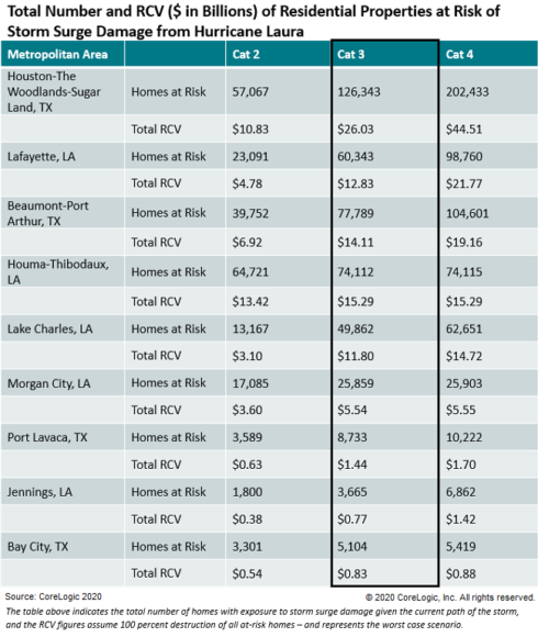
An analysis by global property information, analytics and data-enabled solutions provider, CoreLogic shows that 431,810 single-family and multifamily homes along the Texas and Louisiana coasts with a reconstruction cost value (RCV) of approximately $88.63 billion are at potential risk of storm surge damage from Hurricane Laura based on its projected Category 3 status at landfall.
Corelogic’s estimate was based on information from the NHC as of 8 am EST on Aug. 25.
Katrina
To date, Hurricane Katrina is considered the largest, most expensive natural catastrophe to hit the U.S. If a storm of Katrina’s magnitude were to hit the New Orleans area today, the region would experience even larger economic losses than it did when that destructive torrent made landfall 15 years ago, according to a new report from global reinsurer Swiss Re.
But other, more densely populated regions could fare even worse if the were to be hit by a similar storm, according to Swiss Re.
Katrina made landfall near Buras, Louisiana, on Aug. 29, 2005, as a strong Category 3 hurricane with maximum sustained winds of 125 mph. After having blasted parts of southern Florida earlier in the month as a Category 1 hurricane, Katrina returned to the Gulf of Mexico where it strengthened at one point into a Category 5 storm.
Swiss Re, in its report, 15 Years After Katrina: Would We Be Prepared Today?, said adjusted for inflation, economic losses from Hurricane Katrina stand at approximately $160 billion dollars with the insurance industry picking up around $86 billion — the biggest global insurance loss in history.

Despite a lower population count, as well as significant investment in infrastructure and other measures to protect the area since 2005, if a Katrina-like storm hit New Orleans today, economic losses could hit $175 billion, Swiss Re said.
Swiss Re’s Natural Hazards Experts recreated the storm track and assessed the damage a modern-day Katrina would cause if again placed on a collision course with the city.
They found that even a six-inch rise in the ocean level economic losses could reach $200 billion, with US privately insured losses projected to be at $65 billion. Swiss Re noted that a six-inch ocean level rise could potentially happen by the end of the next decade.
The impact of a Katrina-like storm today on certain other vulnerable cities in the U.S. could be much more damaging, according to Swiss Re. It is “important to note that this potential is dwarfed by a similar event impacting a more populated region with greater residential and commercial assets, like Miami-Dade County, Florida or Houston, Texas.”
The population of Harris County, Texas, where Houston is located, has added well over a million residents over the last 20 years, according to the U.S. Census Bureau. The county’s estimated population as of July 1, 2019, stood at 4,713,325.
By comparison, New Orleans’ population remains significantly decreased from pre-Katrina levels, Swiss Re’s report noted. After Katrina, the city’s population decreased by 52%, from 484,674 in April 2000 to 230,172 in July 2006. As of July 1, 2019, New Orleans’ population had increased to 390,144, according to the Census Bureau.
Harvey
Hurricane Harvey made landfall on Aug. 25, 2017, as a Cat 4 hurricane near Rockport, Texas, where its 130 mile per hour winds caused extensive damage. As it moved eastward along the coast toward Louisiana, the storm produced large areas of extreme rainfall amounts that caused historic flooding in Houston and surrounding areas.
The Insurance Council of Texas recently noted in a media release discussing Harvey’s impact that the “heaviest rainfall in U.S. history was recorded in the city of Beaumont and four days later, the rains ended in Brownsville on August 29.”
The ICT noted the following Harvey-related statistics:
- 93 deaths
- $19.6 Billion in insured losses
- 200,000+ structures damaged or destroyed
- 500,000+ autos damaged or destroyed
- 154,000 homes flooded in Harris County
- 50% of the flooded homes were located outside designated flood plains
- 64% of those homes had no flood insurance
The Texas Windstorm Insurance Association is the property insurer of last resort for wind and hail for counties along the state’s coastline, but Texas insurance companies still write about 59% of windstorm policies along the Texas coast, according to the ICT.
“After Hurricane Harvey, Texas insurance companies paid over $7 billion in auto, business, and homeowner claims, in addition to $363 million paid to TWIA to cover TWIA policyholder losses from this massive storm,” the ICT wrote in its media release.
Rita
According the Louisiana State University AgCenter, no coastal parishes in Louisiana were left unscathed by Hurricane Rita, which blew ashore along the Texas/Louisiana border Sept. 24, 2005, less than a month after Hurricane Katrina hit Southeast Louisiana and Southwest Mississippi.
While not one of the costliest hurricanes on record in the United States, by the end of 2005 Advisen had tagged insured losses from Rita at $6.4 billion.
Was this article valuable?
Here are more articles you may enjoy.
"bring" - Google News
August 26, 2020 at 08:07AM
https://ift.tt/3aX0CR2
Hurricane Laura’s Timing, Direction Bring Harvey, Katrina, Rita to Mind - Insurance Journal
"bring" - Google News
https://ift.tt/38Bquje
Shoes Man Tutorial
Pos News Update
Meme Update
Korean Entertainment News
Japan News Update
Bagikan Berita Ini


Related Posts :
 Mastercard Partners With Bakkt to Bring Cryptocurrency Payments to the Masses - The Wall Street Journal
- Microsoft partners with Shopify to bring merchant listings to Bing, Edge and Microsoft Star - TechCrunch
- 'Bomb cyclone' hits Northern California bringing heavy rain and flooding - NPR
- Forecasters: California Storm Could Bring 'Historic' Rain - Claims Journal
- A slow-moving nor'easter will bring rain and gusty winds to Maine - fox23maine.com
0 Response to "Hurricane Laura’s Timing, Direction Bring Harvey, Katrina, Rita to Mind - Insurance Journal"
Post a Comment