Hurricane forecasters were monitoring a disturbance in the Gulf of Mexico that has a high chance of developing into a depression and is expected to bring several inches of rain to the region.
According to the 7 p.m. Monday update from the National Hurricane Center, the disturbance has a 70% chance of becoming a tropical depression within the next five days. It's also one of three systems forecasters were tracking on Monday evening, including a tropical depression off the East Coast.
UPDATE: Tropical depression expected to form in Gulf of Mexico: What to know Tuesday
Here's what we know from the National Hurricane Center about the tropics as of 7 p.m. Monday.
Gulf of Mexico disturbance

Courtesy of the National Hurricane Center.
Forecasters said a low pressure system will likely develop into a tropical depression late in the week in the Gulf of Mexico.
On Monday evening, an area of disorganized storms was over the Bay of Campeche and is expected to gradually strengthen while it meanders near the coast of Mexico.
By midweek, the system should begin to move north.
The NHC has not said if and where the system will hit the Gulf Coast, but Louisiana could get up to 4 to 10 inches of rain on Friday, with some areas seeing more than 10 inches, regardless of development.

TREE CHECK: Now that hurricane season has begun, it’s time to check all of the larger trees in your landscape. A tree that is sickly, low in v…
The shaded area on the graphic is where a storm could develop and is not a track. The National Hurricane Center releases a track when a tropical depression forms or is about to form.
The categories, in order of increasing strength, are tropical depression, tropical storm and hurricane (categories 1 through 5). Systems are named when they develop into a tropical storm.
Tropical depression in the Atlantic
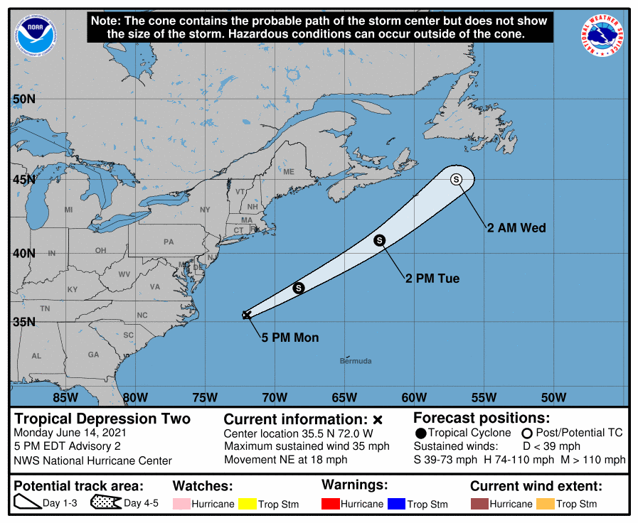
Courtesy of the National Hurricane Center.
A system off the coast of North Carolina strengthened into a tropical depression earlier Monday and will likely develop into the second named tropical storm of the year by tonight, forecasters said. It will be named Bill.
The tropical depression is forecast to move away from the East Coast and therefore doesn't pose an immediate threat to land.
The storm's center was about 200 miles east of Cape Hatteras, North Carolina, as of 7 p.m., according to the National Hurricane Center. It has winds of 35 mph and is moving northeast at 18 mph.

Last year's hurricane season broke several records, including having the most named storms ever on record.
Forecasters said the system is only expected to strengthen slightly after becoming a tropical storm. It will dissipate by Wednesday south of Nova Scotia.
A strong tropical wave off of Africa's west coast was also being monitored Monday evening. It has a 20% (low) chance of developing into a depression within the next five days.
The Atlantic hurricane season runs from June 1 through Nov. 30.
To see more hurricane forecast information, click here.
Don't miss a storm update this hurricane season. Sign up for breaking newsletters. Follow our Hurricane Center Facebook page.
"bring" - Google News
June 15, 2021 at 07:30AM
https://ift.tt/2TB0DFB
Tropical depression likely to form in Gulf, could bring up to 10 inches of rain to Louisiana - NOLA.com
"bring" - Google News
https://ift.tt/38Bquje
Shoes Man Tutorial
Pos News Update
Meme Update
Korean Entertainment News
Japan News Update
Bagikan Berita Ini


0 Response to "Tropical depression likely to form in Gulf, could bring up to 10 inches of rain to Louisiana - NOLA.com"
Post a Comment