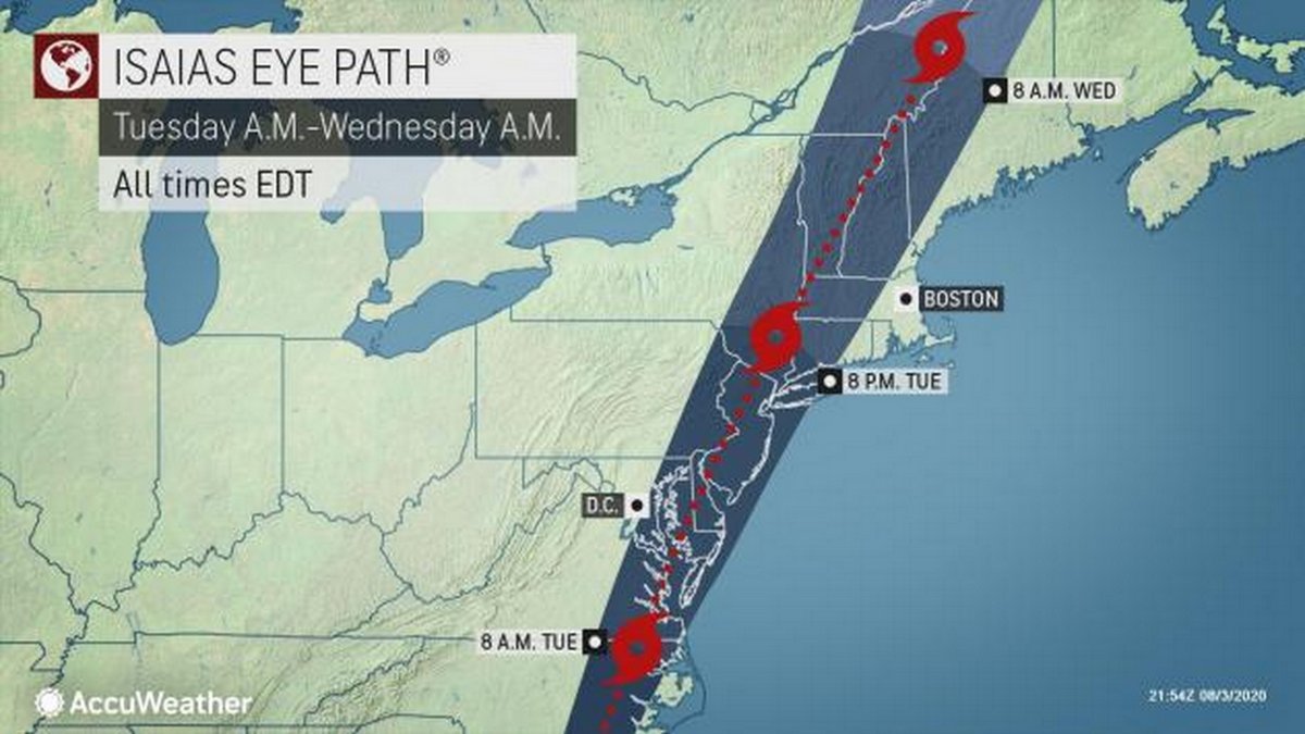

A tropical storm warning has been issued for Massachusetts and Connecticut as now-Hurricane Isaias was nearing landfall along the Carolinas' coasts. Rain in the region is expected to start during the night on Monday and continue through Wednesday.
Isaias is expected to make landfall Monday night as a Category 1 and shift inland, with Accuweather saying the eye of what should then be a tropical storm moving north over the Berkshires by late Tuesday. The National Weather Service in Albany is says it will impact southeast New York by Tuesday night and New England by early Wednesday morning.
"Confidence is increasing with respect to the magnitude of local hazards and impacts," according to NWS. "Locally heavy rainfall and gusty winds are the main impacts from Tropical Storm Isaias."
Depending on the storm's track and intensity, there is the potential for moderate to heavy rain and flooding. High winds could mean damage to roofs and siding, downed trees and lines, and other debris in the roads.
The storm will be accompanied by a drop in temperatures overnight on Monday and with a forecast Tuesday in the mid-60s with rain. Accuweather is predicting rainfall totals of 2 to 4 inches over the Berkshires and Southern Vermont by mid-afternoon on Tuesday and winds of up to 39 mph by 7 p.m.
The tropical storm warning remains in effect. NWS predicts heavy rainfall and gusty winds are the main impacts from Tropical Storm Isaias. There is a chance some of the thunderstorms could produce isolated tornadoes this afternoon into early tonight.
A total of 1 to 4 inches of rainfall is likely. Showers and embedded thunderstorms will become heavier this afternoon into this evening. The strongest winds are also expected this afternoon into this evening.
5PM update on #TropicalStormIsaias. For eastern NY & western New England, expect strong winds (25 to 40mph gusts to 50mph) & heavy rain tomorrow, mainly in the aft'n and evening. Strongest winds in Berkshire and Litchfield Counties. #nywx #mawx #vtwx #ctwx pic.twitter.com/vSaYsKE1AQ
— NWS Albany (@NWSAlbany) August 3, 2020
Strong winds with Very heavy rain expected Tuesday night......
Winds in the Highest Elevations will likely gust over 50mph.Strong Tstorms east of the track will be possible...even isolated tornadoes.
Wind Advisories posted locally and Tropical Storm Warnings east issued. pic.twitter.com/IPplaAj3hH
— Steve Caporizzo (@SteveCaporizzo) August 4, 2020
Tropical Storm Isaias will be here in 24 hours, bringing with it strong wind gusts, rain, and perhaps severe thunderstorms. Read more in our updated blog: https://t.co/3vvufF56AH pic.twitter.com/HPesIJQRnN
— Anthony Macari (@Anthony_Macari) August 3, 2020
Hurricane #Isaias has intensified further, now has max sustained winds of 85 mph, with the core of those winds and associated storm surge about to sweep into coastal N.C. https://t.co/lwl2WfSV1Y
— Capital Weather Gang (@capitalweather) August 4, 2020
Tags: hurricane, rain,
"bring" - Google News
August 04, 2020 at 09:07AM
https://ift.tt/2Pl2UPY
Isaias to Bring Rain, Wind to Northeast - iBerkshires.com
"bring" - Google News
https://ift.tt/38Bquje
Shoes Man Tutorial
Pos News Update
Meme Update
Korean Entertainment News
Japan News Update
Bagikan Berita Ini


0 Response to "Isaias to Bring Rain, Wind to Northeast - iBerkshires.com"
Post a Comment