Connecticut is bracing for a strong nor’easter that is expected to bring gusty winds, at least an inch of rain and heavy, wet snow in northern areas of the state.
While northwestern and northeastern Connecticut have the best chance of snow accumulation, snow is also expected to mix with rain in the southern part of the state on Saturday.
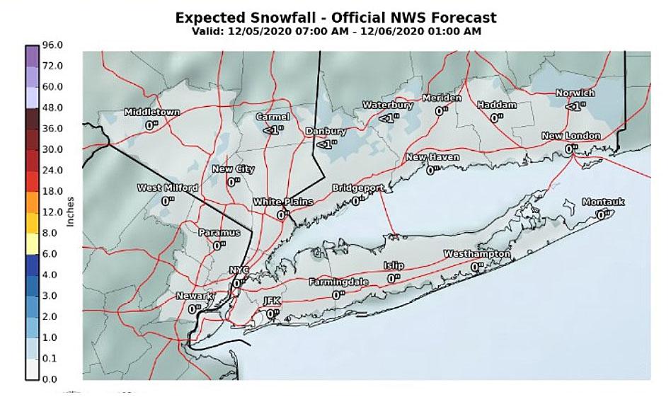
The National Weather Service said highest snowfall totals of 4 to 6 inches, were expected in northeast Connecticut and between 2 to 5 inches in northern Litchfield County.
Between 1 and 3 inches were forecast for central Connecticut and less than an inch along the shoreline.
Farther north, the high terrain of Worcester and Middlesex counties of Massachusetts could get nailed with up to a foot of snow Saturday, the NWS Boston office said.
“Snow totals are highly dependent on the storm track, and the timing of when rain switches to snow. Highest amounts may shift east if the storm tracks farther offshore,” it said.
Saturday night could look — and feel — like winter with freshly fallen snow and wind chills between 15 and 25 degrees, across Connecticut, the NWS said.
Early Friday afternoon, Tolland and Windham counties in northeastern Connecticut were placed under a Winter Storm Watch from Saturday morning through Saturday night.
Later Friday, a Winter Weather Advisory was posted for northern Litchfield County from 7 a.m. Saturday to 7 a.m. Sunday with 2 to 5 inches of snow likely.
“Plan on slippery road conditions Saturday afternoon into the evening,” the advisory said. “The snow will mix with rain in the late morning into the early afternoon before changing to all snow in the late afternoon into the evening and becoming briefly heavy.”
The heavy, wet snow and gusty winds could result in scattered power outages and some downed trees.
“The first nor’easter of the season is on its way, and we’re ready to respond,” Eversource posted on its Facebook page. “We’ve brought in outside crews to help, and have stockpiled extra equipment like transformers, poles, and wires to ensure we’re ready to repair any damage we may see from this storm.”
It could also cause some difficult travel conditions on Saturday.
Highest wind gusts of up to 45 mph are expected in eastern Connecticut. Western Connecticut is expected to have peak wind gusts near 35 mph. Strongest gusts across the state are expected between 2 and 11 p.m.
Rain from the storm started before 5 p.m. Friday in western Connecticut. Precipitation is expected to turn over to snow by late Saturday morning in Litchfield County and northeastern Connecticut.
On Saturday, temperatures are expected to drop throughout the day with overnight lows falling well below freezing. That could cause slippery road conditions Sunday morning.
The colder temperatures could cause quicker transition to snow for area like Danbury, Middletown and Oxford to receive a half-inch of snow.
Along the shoreline, mostly rain is expected with accumulations between 1 to 1.5 inches possible.
While “a few wet snowflakes are possible” along the state’s coastline late Saturday afternoon, the weather service said no accumulation is expected based on the latest predictions.
Coastal flooding is likely Saturday morning and during high tide in the early afternoon.
On Oct. 30, Connecticut saw its first widespread snowfall and coldest temperatures since April. It was the sixth time it snowed in October in the 115 years since the NWS has been keeping records in the state.
Snowfall totals from that storm exceeded 5 inches in Goshen, Coventry and Pomfret.
Last winter, snow was also a rarity in Connecticut with just 10.2 inches recorded at Sikorsky Memorial Airport in Stratford. The average snowfall for Stratford is 25.2 inches.
Even in Norfolk, the Icebox of Connecticut, last winter’s snowfall was 26 inches below normal.
Connecticut and most of the Northeast are expected to have above-average temperatures this winter, according to the National Oceanic and Atmospheric Administration’s winter forecast released in mid-October.
It also says there is an equal chance for above or below normal precipitation. That means there’s no tilt in the odds of having more or less precipitation.
The early part of next week looks cold with temperatures falling into the upper teens and 20s during the night.
"bring" - Google News
December 05, 2020 at 06:33AM
https://ift.tt/3lIpWxR
NWS: Nor’easter to bring some snow, frigid wind chills to CT - CTPost
"bring" - Google News
https://ift.tt/38Bquje
Shoes Man Tutorial
Pos News Update
Meme Update
Korean Entertainment News
Japan News Update
Bagikan Berita Ini


Related Posts :
 Jennifer Lopez and Ben Affleck bring kids along for 'Hamilton' date night - Page Six
- LMH works to partner with KU to bring better patient services to Kansans - WIBW
- New food market opens, hopes to bring fresh, affordable food to the community - WECT
- These money and investing tips can bring your portfolio into focus - MarketWatch
- High winds threaten to bring renewed fury to destructive Caldor Fire in NorCal - KTLA
0 Response to "NWS: Nor’easter to bring some snow, frigid wind chills to CT - CTPost"
Post a Comment