On the first full day of spring, we will have some big changes in the weather.
First, there is a Dense Fog Advisory along the Long Island Sound shoreline. The advisory is in effect until noon for the western shoreline and to 2 p.m. along the eastern shoreline.
The fog will be so thick on the Sound, the National Weather Service says low visibility will make navigation difficult. “If you must navigate, proceed with caution. Use proper fog signals. Make sure all running lights are on. Remember to useyour radar and compass.”
The big changes in the weather will be caused by clashing warm and cold fronts.
That could trigger some strong thunderstorms this afternoon. Western Connecticut has the best chance of severe thunderstorms that could have winds as strong as 40 mph.
Warm and moist air today along with breezy winds will likely lead to snow melt in the higher elevations of the southern Green Mountains of Vermont, which could lead to some flooding in the next few days along the Housatonic and Connecticut rivers in the state.
A frontal system tracking through the Great Lakes will lift a warm front north through the area this morning, followed by a cold front this evening.
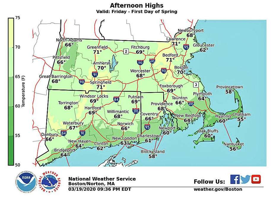
The high temperature near 68 will peak around 4 p.m. Friday. After that, the cold front will bring a 30-degree temperature drop. By 7 a.m., the temperature will be 38 degree.
Saturday and Sunday nights will be cold with temperatures in the 20s across Conneticut.
Any showers and thunderstorms quickly come to an end tonight as the cold front pushes off shore and high pressure begins to build north of the region.
Despite plenty of sunshine, Saturday will be noticeably cooler, with highs near normal with the upper 40s to around 50.
And once the weekend is over there is a chance of rain and ... some snow.
The forecast
Friday: A 50 percent chance of showers. Patchy fog before noon. Otherwise, cloudy, with a high near 67. Southwest wind 5 to 11 mph, with gusts as high as 24 mph.
Friday Night: A chance of showers and thunderstorms before 9pm, then a slight chance of showers between 9pm and midnight. Mostly cloudy, with a low around 37. West wind 8 to 13 mph. Chance of precipitation is 50 percent.
Saturday: Mostly sunny, with a high near 46. North wind 8 to 10 mph, with gusts as high as 20 mph.
Saturday Night: Mostly clear, with a low around 22. North wind 5 to 7 mph.
Sunday: Sunny, with a high near 41.
Sunday Night: Increasing clouds, with a low around 29.
Monday: A chance of rain and snow between 9am and noon, then rain likely. Cloudy, with a high near 40. Chance of precipitation is 70 percent.
Monday Night: Rain likely before 11 p.m, then rain and snow likely. Mostly cloudy, with a low around 31. Chance of precipitation is 70 percent.
"bring" - Google News
March 20, 2020 at 06:59PM
https://ift.tt/2IZmxdl
Cold front to bring big temperature drop, possible T storms - CTPost
"bring" - Google News
https://ift.tt/38Bquje
Shoes Man Tutorial
Pos News Update
Meme Update
Korean Entertainment News
Japan News Update
Bagikan Berita Ini


Related Posts :
 Who will the Lightning bring to training camp? - Tampa Bay Times
- NAACP working to bring branch to Weld - Greeley Tribune
- Urbandale reconsiders plan to bring students back for in-person classes - Des Moines Register
- Montgomery County Schools to Bring Students Back to Classroom in Phases - NBC4 Washington
- Microsoft and Google team up to bring more web apps to the Play Store - Engadget
0 Response to "Cold front to bring big temperature drop, possible T storms - CTPost"
Post a Comment